Mount Tronador, only 90 kilometers from downtown Bariloche, is one of the most accessible and popular destinations in Patagonia.
The ‘thundering mountain’ is the highest peak in Nahuel Huapi National Park at 3.491 meters above sea level. It gets its evocative name from the crashing sound of its melting glaciers when they fall.
Cerro Tronador is a volcanic mountain, or stratovolcano, inactive for the last 60,000 years. Visitors need not worry — chances are slim it will wake up now.
This daytime tour from Bariloche can be done on one’s own by renting a car or booking a tour (feel free to get in touch with us to arrange it).
Due to the combination of mountain roads and rough weather conditions in winter, driving is only recommended for experienced drivers who won’t get too distracted by the stunning scenery.
A 4×4 vehicle is required in the winter months (June, July and August).
The only way to get close to the mountain on public transportation is to take the bus from Bariloche to El Bolson and ask the driver to let you off at the Tronador diversion.
Hitchhiking isn’t common on this stretch, but it may be the only option to avoid getting stranded if dropped off by the bus.
⇒ Explore activities in around San Carlos de Bariloche
Argentina’s Historic Route 40
The road that initially leads visitors to Mount Tronador is the historic Route 40.
One of the longest roads in the world, RN 40 is Argentina’s counterpart to the U.S.A.’s Route 66, Australia’s Stuart Highway, and Canada’s Trans-Canada highway.
The road is also known as ‘Libertador General Don José de San Martín,’ in honor of revolutionary and star of the five-peso bill.
‘Ruta 40’ stretches across Argentina from La Quiaca in the northern Jujuy province to Cabo las Vírgenes, at the tip of the country in Santa Cruz province.
For many years, RN 40 was a gravel road memorialized for its ruggedness by travelers such as English novelist, Bruce Chatwin, who wrote about it in his classic, La Patagonia.
In 2004, Route 40 was decreed a National Site of Tourist Interest and paving began. Today Route 40 is almost fully paved.
Argentina and Chile’s Natural Boundary
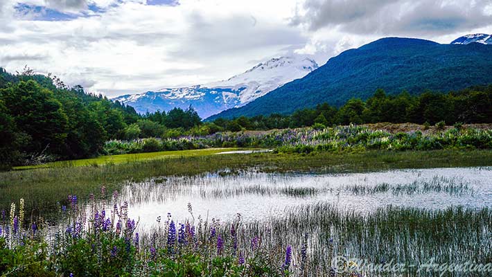
From Bariloche, go south on route 40 for about 15 kilometers until reaching Gutierrez Lake in a zone known as ‘the Water Division.’
This huge wetland, called ‘Mallín’ in the indigenous Mapuche language, was formed during a stationary phase of the Ice-Age.
When the glaciers reemerged, they formed what today is the Gutierrez Lake basin.
This huge wetland changed the direction of the water flow. On one hand Gutierrez Lake is part of the Nahuel Huapi basin which, along with the Limay river, flows out to the Atlantic Ocean, while Mascardi Lake like most western side lakes and rivers, flows into the Pacific.
Until the 18th century the natural watersheds were considered the natural border between Chile and Argentina, but when explorer and academic, Francisco Pascasio Moreno proved that the course of the rivers could be changed, the government declared that the boundary between the countries should cross from the highest peaks of the Andes Mountain ranges, including Mount Tronador.
Activities on Lake Gutiérrez: ‘Eye of God’ Lake
The glacier transformation that took part in this region millions of years ago created magical scenery of wild nature surrounded by various-sized lakes.
Gutiérrez Lake is in a valley surrounded by Otto hill, Cathedral and De la Ventana mountains. The native Tehuelches named this lake, ‘The eye of God’ and later the Mapuche tribe called it Carre Lauquen, meaning ‘Green Lake.’
After the Julio Argentino Roca-led genocide against indigenous peoples, in 1877 the original names were supplanted by ‘Gutiérrez’ — the name of a the head of the Ministry of the Interior, who was also a mentor to Moreno.
Pristine Gutiérrez Lake is perfect for fishing, kayaking or stand up paddle. Since it is sourced by rainwater and not melting glaciers, it’s warmer than Nahuel Huapi Lake and has many small sandy beaches and camping areas along its shores.
The Coihue forest, named after the evergreen tree of the same name, offers a lush area for horse riding and trekking tours.
Villa Los Coihues also has a paleontological museum where visitors can appreciate the geological evolution of Patagonia, one of the densest areas for dinosaur fossil discoveries in the world.
To find the ranger post walk two kilometers from the Coihue Village along the western part of the Gutierrez Lake, or take the public bus n°50 on the frontage road.
Heading up from Mascardi Village
For those visiting Mount Tronador and the Black Glacier on their own it’s important to check the car’s oil levels in the ACA gas station in Mascardi Village, because it’s the last place to do so before ascending.
This outpost, 27 kilometers from Coihue Village, was built 1940 by the Christiani & Nielsen construction company, famed for constructing the Civic Center in Bariloche.
It’s is also a lookout point of the next stop, Mascardi Lake, known as ‘Seven Colors Lake’ because of the color variation it has during all seasons of the year.
Named after a 17th-century Jesuit missionary, its surface area is 40 square kilometers. The 200 meter-deep lake is formed in a V shaped with two arms formed from the melting glacier’s path. The Cathedral arm is seen first,where the Guillelmo stream flows into it. This crossing point is where to verge right onto the rubble province road 82 that leads toward Tronador and Cascada de los Alerces.
The Tronador Route & Isla Corazón
Five hundred meters up the road is the the ranger station where visitors pay the approximately US$10 entrance fee to enter Nahuel Huapi National Park (important: it can only be paid in cash — in pesos, other currencies are not accepted).
The road then goes along the Playa Negra (Black Beach) with a view of Mount Bonete, the Ande’s fifth highest peak in the background.
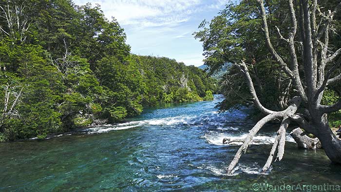
After nine kilometers the road reaches the Los Rápidos Campground. The area get its name, meaning the ‘the rapids’ because this is where the Manso river flows off the Rio Manso Glacier – one of the fourteen on Mount Tronador – and finally flows out into Mascardi Lake.
The Manso River contains a great quantity of glacier minerals so it appears brilliant green in sunlight. During the fishing season, this is a perfect place for fisherman to cast a line — it’s considered fairly easy to catch native Brook, Brown and Rainbow trout here.
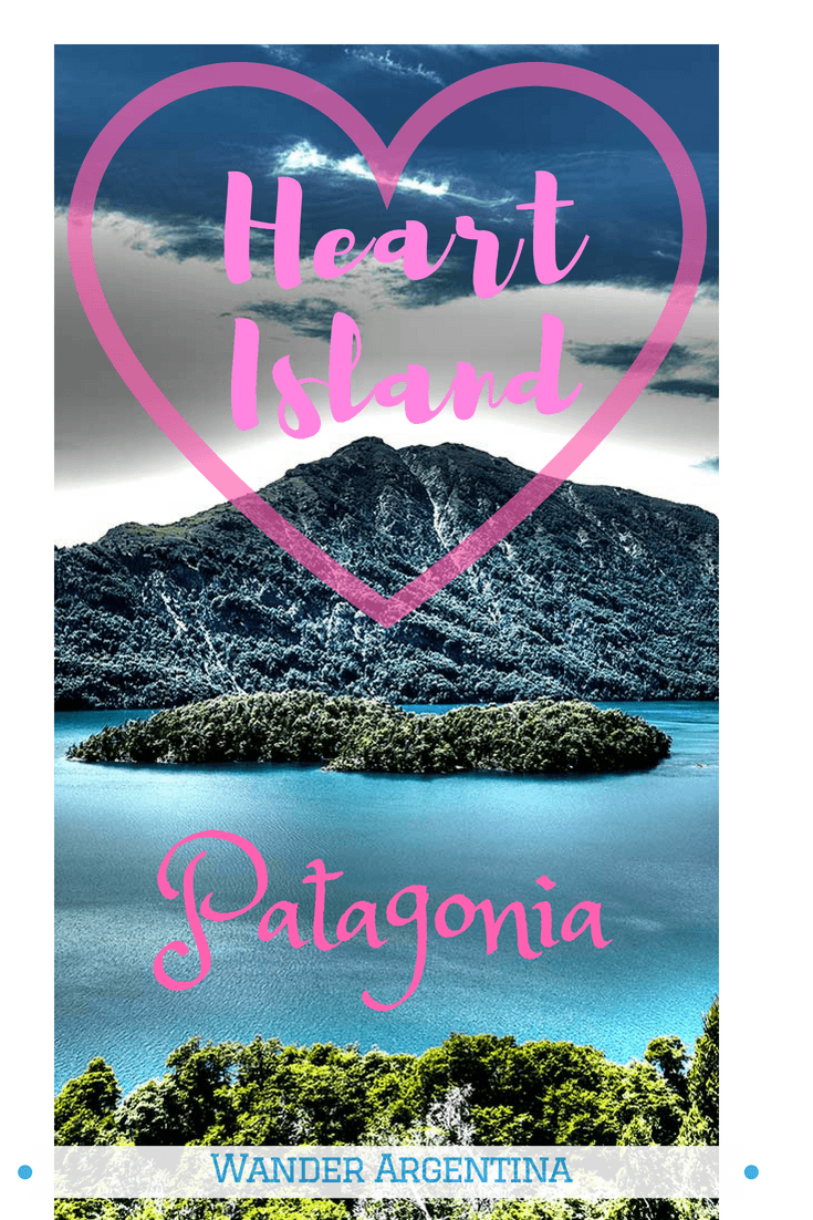
Fifteen minutes up the road from Los Rapidos is the lookout point for Isla Corazón (Heart Island) — or ‘Piuké Huapí’ in the Mapuche language — in the Tronador arm of Mascardi Lake.
This heart-shaped island gets its name from a Mapuche-style Romeo and Juliet drama involving ancient enemy tribes.
The legend goes that two young lovers were separated by their rival families, so they kept their relation secret until they were caught together and rounded up on the border of Mascardi Lake.
The two lovers had no other option but to jump into the cold water to try and swim to the opposite shore.
While crossing they started to feel the symptoms of hypothermia so they embraced each other to keep their bodies warm. According to the legend, after the lovers drowned, they were transformed into a heart shaped island.
Not surprisingly, this romantic spot enjoys a reputation as a unique place to pop the question.
Trekking to Pampa Linda
From Isla Corazon it takes about 30 minutes to get to the next destination, Pampa Linda. This camping area with a small restaurant is where lunch is served on the official tour.
This is the spot with the best views of the Mount Tronador and its three peaks — the western peak is in Chile, the eastern one in Argentina, and the middle one marks the border point between the two countries.
Mount Tronador has fourteen glaciers — products of the last glacial period that occurred more than 10,000 years ago.
Mount Tronador is one of the most important glacier-accumulation areas of Patagonia, having seven principal glaciers, three on the Chilean side and four on the Argentinean side. Bring a good pair of binoculars, to see the Manso Glacier and the Castaño Overo Glaciers in detail.
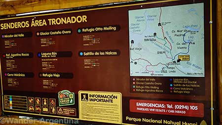
Pampa Linda is the starting point for various treks from easy to difficult, ranging from one hour to two days.
The ‘Saltillo de las Nalcas’ trek to a waterfall is an easy family option that takes about 1.5 hours to complete.
There are also guided tours to climb the glaciers offered for those in decent shape who have the proper equipment.
It’s not recommended to for amateurs unfamiliar with the area to hike the glaciers without a guide. Those who do will want to fill out the online trekking registration and make sure to inform to the park rangers of their plans.
The Otto Meiling Mountain Hut
The adventurous who want to climb the glacier may opt to do a five to seven hour trek 1,200 meters up from Pampa Linda to the Otto Meiling Shelter.
The shelter is named for its founder, a German mountaineer who immigrated to Argentina (along with many other Germans) and built the hut in the 1950’s. Meiling continued to climb in the area well into his 80s.
During winter season the shelter has no service, but from December to April it provides meals, decent accommodation and guided excursions of varying difficulty.
It’s located between the Castaño Overa and the Alerce glaciers, 2000 meters above sea level. Otto Meiling hut has one of the most privileged panoramic views of Pampa Linda, Paso de las Nubes Valley, the López, Bonete, Righi, and Mount Cathedral.
Otto Meiling is one of the most popular mountain huts of Bariloche, but it’s not part of the Official Tronador Tour.
Previous snow and ice climbing experience is required due to the danger posed by deep crevasses. Anon peak, on the Argentina side is the easiest of the three peaks to climb, but many predict that it will become inaccessible within a few years due to destabilization caused by the warming of the upper troposphere.
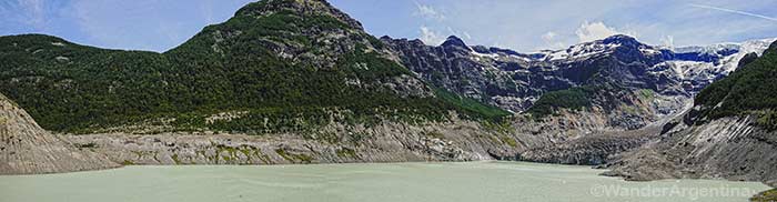
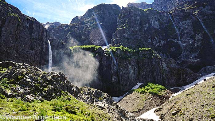
The Black Glacier
An unpaved road climbs up to the Ventisquero Negro (Black Glacier), a reconstituted glacier full of sediment that gives it its namesake black pigmentation.
A new lake that is less than 100 years old at the bottom of the glacier has the same green hue as the Manso River and other bodies of water in the region.
Mount Tronador is pure ice at its peak, surrounded by hundred-meter cliffs that generate the rumbling avalanches and landslides.
The debris from the avalanches feed the lower lip of the glacier, giving it its dirty appearance.
At the conclusion of this trip visitors can trek to the Garganta del Diablo (Devil’s Throat — not to be confused with Iguazú’s Devils Throat) waterfall, and be treated to a beautiful view of the natural melting cascade.
On May 29th of 2009 a shocking breakage happened in the dam that contains the Black Glacier, flooding Pampa Linda.
Residents were evacuated by helicopter and luckily there were no fatalities.
As one of the most accessible glaciers in South America, the event caused introspection into how global warming could wreak havoc on nearby populations such as Pampa Linda any day.
Argentina’s government is tracking the glacial drift — the country is among the top 15 countries for ice-surface levels, although they are melting.
The country’s 16,968 glaciers combined are 41 times the size of Buenos Aires.
According to a study by the Argentine Institute of Snow Science, Glaciology and Environmental Sciences (IANIGLA), from the 1970s until now, the the lower tongue of the Black Glacier has experienced a significant loss of ice and it may be gone by 2030.
Visitors who experience the constant thundering crashes of ice of the glacier will understand first-hand how import preservation of this pristine environment is for future generations.
— Daniela Massolo
⇒ If you’d like to book an excursion to Mount Tronador and Black Glacier Day Trip, get in touch with us!
→ Wander Argentina can also arrange reasonably-priced custom trips to Patagonia, including Mount Tronador along with other attractions in Bariloche, alone or in combination with other Argentina destinations — get in touch via our contact form.
→ Read our comprehensive local’s guide to Bariloche, The ‘Switzerland of Argentina’
→ Check out a customizable four-day Bariloche itinerary
→ Read about the Andean Lakes Crossing Tour, another worthwhile excursion in the same area.
Final tips to Visit Mount Tronador
- The total trip to Mount Tronador from Bariloche is about 77 kilometers. The black glacier is another 7 kilometers down the road. The route goes along national Route 40 for 37 kilometers and then along provincial Route 82 for 40 kilometers.
- The route is one-way during peak hours
— Heading toward Mount Tronador the road is open from 10.30 a.m. to 2 p.m.
— Returning from the mountain, the road is open from 4 p.m.— 6p.m
- Two-way traffic permitted: From 7.30p.m. to 9 a.m.